Clarkedale, Arkansas | |
|---|---|
 | |
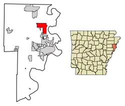 Location of Clarkedale in Crittenden County, Arkansas. | |
 Clarkedale, Arkansas | |
| Coordinates: 35°18′33″N 90°14′10″W / 35.30917°N 90.23611°W | |
| Country | United States |
| State | Arkansas |
| County | Crittenden |
| Area | |
| • Total | 11.44 sq mi (29.62 km2) |
| • Land | 11.44 sq mi (29.62 km2) |
| • Water | 0.00 sq mi (0.00 km2) |
| Elevation | 230 ft (70 m) |
| Population (2020) | |
| • Total | 336 |
| • Density | 29.38/sq mi (11.34/km2) |
| Time zone | UTC-6 (Central (CST)) |
| • Summer (DST) | UTC-5 (CDT) |
| ZIP code | 72325 |
| Area code | 870 |
| FIPS code | 05-14050 |
| GNIS feature ID | 76622[2] |
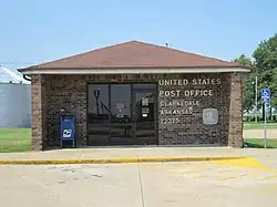
Clarkedale is a town[3] in Crittenden County, Arkansas, United States. Per the 2020 census, the population was 336.[4] Clarkedale incorporated on November 15, 2000.[5]

Clarkedale Highway sign
Demographics
| Census | Pop. | Note | %± |
|---|---|---|---|
| 2010 | 371 | — | |
| 2020 | 336 | −9.4% | |
| U.S. Decennial Census[6] 2010[7] 2020[8] | |||
2020 census
| Race / Ethnicity | Pop 2010[7] | Pop 2020[8] | % 2010 | % 2020 |
|---|---|---|---|---|
| White alone (NH) | 303 | 276 | 81.67% | 82.14% |
| Black or African American alone (NH) | 50 | 29 | 13.48% | 8.63% |
| Native American or Alaska Native alone (NH) | 3 | 0 | 0.81% | 0.00% |
| Asian alone (NH) | 1 | 0 | 0.27% | 0.00% |
| Pacific Islander alone (NH) | 0 | 0 | 0.00% | 0.00% |
| Some Other Race alone (NH) | 0 | 0 | 0.00% | 0.00% |
| Mixed Race/Multi-Racial (NH) | 2 | 19 | 0.54% | 5.65% |
| Hispanic or Latino (any race) | 12 | 12 | 3.23% | 3.57% |
| Total | 371 | 336 | 100.00% | 100.00% |
Note: the US Census treats Hispanic/Latino as an ethnic category. This table excludes Latinos from the racial categories and assigns them to a separate category. Hispanics/Latinos can be of any race.
Education
Clarkedale is in the Marion School District.[9] Its comprehensive high school is Marion High School.
References
- ↑ "2020 U.S. Gazetteer Files". United States Census Bureau. Retrieved October 29, 2021.
- 1 2 U.S. Geological Survey Geographic Names Information System: Clarkedale, Arkansas
- ↑ Local.Arkansas.gov - Clarkedale, retrieved September 3, 2012
- ↑ "Clarkedale city, Arkansas". United States Census Bureau. Retrieved April 15, 2022.
- ↑ "Boundary Changes". Geographic Change Notes: Arkansas. Population Division, United States Census Bureau. January 1, 2010. Archived from the original on July 31, 2012. Retrieved June 13, 2011.
- ↑ "Decennial Census of Population and Housing by Decades". US Census Bureau.
- 1 2 "P2 HISPANIC OR LATINO, AND NOT HISPANIC OR LATINO BY RACE – 2010: DEC Redistricting Data (PL 94-171) – Clarkedale city, Arkansas". United States Census Bureau.
- 1 2 "P2 HISPANIC OR LATINO, AND NOT HISPANIC OR LATINO BY RACE – 2020: DEC Redistricting Data (PL 94-171) – Clarkedale city, Arkansas". United States Census Bureau.
- ↑ "2020 CENSUS - SCHOOL DISTRICT REFERENCE MAP: Crittenden County, AR" (PDF). U.S. Census Bureau. Retrieved September 22, 2022.
Municipalities and communities of Crittenden County, Arkansas, United States | ||
|---|---|---|
| Cities | 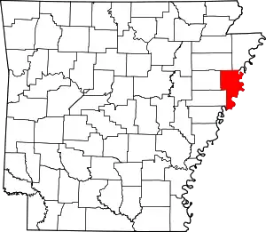 Map of Arkansas highlighting Crittenden County | |
| Towns | ||
| Unincorporated communities | ||
This article is issued from Wikipedia. The text is licensed under Creative Commons - Attribution - Sharealike. Additional terms may apply for the media files.