Canada, Kentucky | |
|---|---|
 Post office in Canada, Kentucky | |
 Canada, Kentucky | |
| Coordinates: 37°36′20″N 82°19′28″W / 37.60556°N 82.32444°W | |
| Country | United States |
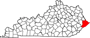
| State | Kentucky |
| County | Pike |
| Elevation | 833 ft (254 m) |
| Time zone | UTC-5 (Eastern (EST)) |
| • Summer (DST) | UTC-4 (EDT) |
| ZIP code | 41519[1] |
| Area code | 606 |
| GNIS feature ID | 507642[2] |
Canada is an unincorporated community in Pike County, Kentucky. Canada is located on U.S. Route 119, 13.8 miles (22.2 km) northeast of Pikeville.[3]
There are two possible scenarios for the origin of the name "Canada". One possible explanation being that Canada (or “kanata”) is the Huron-Iroquois word for settlement, since the area once had a large population of Native Americans. The other explanation involves Zebulon Pike, a general in the War of 1812 who most of Pike County is named after. Pike died in Canada, which leads to this being a possible origin of the name "Canada".
References
- ↑ "Canada ZIP Code". zipdatamaps.com. 2022. Retrieved November 11, 2022.
- ↑ "Canada". Geographic Names Information System. United States Geological Survey, United States Department of the Interior.
- ↑ State Primary Road System: Pike County (PDF) (Map). Kentucky Transportation Cabinet. 2012. Retrieved September 20, 2012.
This article is issued from Wikipedia. The text is licensed under Creative Commons - Attribution - Sharealike. Additional terms may apply for the media files.