Cañasgordas | |
|---|---|
Municipality and town | |
.svg.png.webp) Flag | |
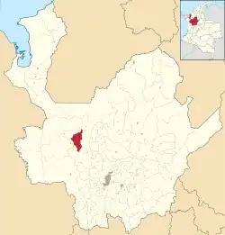 Location of the municipality and town of Cañasgordas in the Antioquia Department of Colombia | |
 Cañasgordas Location in Colombia | |
| Coordinates: 6°44′59″N 76°1′33″W / 6.74972°N 76.02583°W | |
| Country | |
| Department | |
| Subregion | Western |
| Area | |
| • Total | 391 km2 (151 sq mi) |
| Elevation | 1,320 m (4,330 ft) |
| Population (Census 2018[2]) | |
| • Total | 13,595 |
| • Density | 35/km2 (90/sq mi) |
| Time zone | UTC-5 (Colombia Standard Time) |
Cañasgordas is a town and municipality in Antioquia Department, Colombia.
Climate
Cañasgordas has a tropical rainforest climate (Af) with heavy rainfall year-round.
| Climate data for Cañasgordas | |||||||||||||
|---|---|---|---|---|---|---|---|---|---|---|---|---|---|
| Month | Jan | Feb | Mar | Apr | May | Jun | Jul | Aug | Sep | Oct | Nov | Dec | Year |
| Average high °C (°F) | 27.1 (80.8) |
27.6 (81.7) |
27.5 (81.5) |
26.9 (80.4) |
26.6 (79.9) |
26.7 (80.1) |
27.0 (80.6) |
27.3 (81.1) |
27.0 (80.6) |
26.1 (79.0) |
26.1 (79.0) |
26.5 (79.7) |
26.9 (80.4) |
| Daily mean °C (°F) | 21.6 (70.9) |
21.7 (71.1) |
21.8 (71.2) |
21.7 (71.1) |
21.6 (70.9) |
21.7 (71.1) |
21.7 (71.1) |
21.7 (71.1) |
21.5 (70.7) |
21.1 (70.0) |
21.2 (70.2) |
21.4 (70.5) |
21.6 (70.8) |
| Average low °C (°F) | 16.0 (60.8) |
16.2 (61.2) |
16.5 (61.7) |
16.9 (62.4) |
17.1 (62.8) |
17.0 (62.6) |
16.8 (62.2) |
16.7 (62.1) |
16.7 (62.1) |
16.6 (61.9) |
16.6 (61.9) |
16.4 (61.5) |
16.6 (61.9) |
| Average rainfall mm (inches) | 90.1 (3.55) |
96.3 (3.79) |
140.7 (5.54) |
244.9 (9.64) |
273.9 (10.78) |
203.6 (8.02) |
158.3 (6.23) |
177.3 (6.98) |
262.7 (10.34) |
308.5 (12.15) |
289.2 (11.39) |
150.7 (5.93) |
2,396.2 (94.34) |
| Average rainy days | 11 | 10 | 13 | 19 | 21 | 17 | 17 | 16 | 20 | 24 | 21 | 14 | 203 |
| Average relative humidity (%) | 85 | 84 | 84 | 86 | 86 | 86 | 85 | 85 | 85 | 86 | 87 | 86 | 85 |
| Mean monthly sunshine hours | 167.4 | 146.8 | 145.7 | 108.0 | 114.7 | 129.0 | 148.8 | 139.5 | 120.0 | 111.6 | 123.0 | 139.5 | 1,594 |
| Mean daily sunshine hours | 5.4 | 5.2 | 4.7 | 3.6 | 3.7 | 4.3 | 4.8 | 4.5 | 4.0 | 3.6 | 4.1 | 4.5 | 4.4 |
| Source: IDEAM[3] | |||||||||||||
References
- ↑ "Municipalities of Colombia". statoids. Retrieved 26 April 2020.
- ↑ "Censo Nacional de Población y Vivienda 2018" (in Spanish). DANE. Retrieved 26 April 2020.
- ↑ "Data". www.ideam.gov.co. Retrieved 2020-09-01.
This article is issued from Wikipedia. The text is licensed under Creative Commons - Attribution - Sharealike. Additional terms may apply for the media files.