| Côle | |
|---|---|
.JPG.webp) The Côle at Condat-sur-Trincou | |
 | |
| Location | |
| Country | France |
| Physical characteristics | |
| Source | |
| • location | Firbeix |
| • coordinates | 45°34′59″N 00°58′01″E / 45.58306°N 0.96694°E |
| • elevation | 370 m (1,210 ft) |
| Mouth | |
• location | Dronne |
• coordinates | 45°22′08″N 00°41′05″E / 45.36889°N 0.68472°E |
• elevation | 105 m (344 ft) |
| Length | 51.5 km (32.0 mi) |
| Basin size | 172 km2 (66 sq mi) |
| Basin features | |
| Progression | Dronne→ Isle→ Dordogne→ Gironde estuary→ Atlantic Ocean |
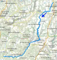
The Côle (French: la Côle) is a 51.5 km (32.0 mi) long river in the Dordogne département, south-central France.[1] It rises near le Châtenet, a hamlet in Firbeix. It flows generally southwest. It is a left tributary of the Dronne into which it flows between Condat-sur-Trincou and Brantôme.
Communes along its course
This list is ordered from source to mouth: Firbeix, La Coquille, Mialet, Saint-Jory-de-Chalais, Saint-Romain-et-Saint-Clément, Thiviers, Saint-Jean-de-Côle, Saint-Pierre-de-Côle, La Chapelle-Faucher, Condat-sur-Trincou, Brantôme
References
Wikimedia Commons has media related to Côle.
This article is issued from Wikipedia. The text is licensed under Creative Commons - Attribution - Sharealike. Additional terms may apply for the media files.