Bass Lake, Ohio | |
|---|---|
 Bass Lake  Bass Lake | |
| Coordinates: 41°33′12″N 81°13′35″W / 41.55333°N 81.22639°W | |
| Country | United States |
| State | Ohio |
| County | Geauga |
| Township | Munson |
| Area | |
| • Total | 1.03 sq mi (2.66 km2) |
| • Land | 0.89 sq mi (2.31 km2) |
| • Water | 0.14 sq mi (0.35 km2) |
| Elevation | 1,151 ft (351 m) |
| Population (2020) | |
| • Total | 530 |
| • Density | 593.51/sq mi (229.18/km2) |
| Time zone | UTC-5 (Eastern (EST)) |
| • Summer (DST) | UTC-4 (EDT) |
| ZIP Code | 44024 (Chardon) |
| Area code | 440 |
| FIPS code | 39-04136 |
| GNIS feature ID | 2812820[2] |
Bass Lake is a census-designated place (CDP) in Geauga County, Ohio, United States, corresponding to the unincorporated community of West Bass Lake. The area was first listed as a CDP prior to the 2020 census.[2]
The CDP is in the northwest part of Geauga County, in northeastern Munson Township. It is on the northwest side of Bass Lake, a natural lake on the Chagrin River, and extends up the valley side to the northwest as far as Wilson Mills Road at the top of the hill. It is 2 miles (3 km) southwest of Chardon, the Geauga county seat, and 27 miles (43 km) east of downtown Cleveland.
Demographics
| Census | Pop. | Note | %± |
|---|---|---|---|
| 2020 | 530 | — | |
| U.S. Decennial Census[3] | |||
References
- ↑ "ArcGIS REST Services Directory". United States Census Bureau. Retrieved September 20, 2022.
- 1 2 "Bass Lake Census Designated Place". Geographic Names Information System. United States Geological Survey, United States Department of the Interior.
- ↑ "Census of Population and Housing". Census.gov. Retrieved June 4, 2016.
Municipalities and communities of Geauga County, Ohio, United States | ||
|---|---|---|
| City | 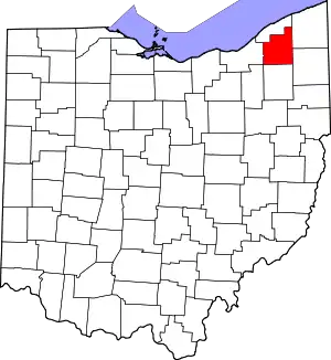 Map of Ohio highlighting Geauga County | |
| Villages | ||
| Townships | ||
| CDPs | ||
| Unincorporated communities | ||
| Footnotes | ‡This populated place also has portions in an adjacent county or counties | |
This article is issued from Wikipedia. The text is licensed under Creative Commons - Attribution - Sharealike. Additional terms may apply for the media files.