Ava, Arkansas | |
|---|---|
 Ava  Ava | |
| Coordinates: 34°52′10″N 93°12′20″W / 34.86944°N 93.20556°W | |
| Country | United States |
| State | Arkansas |
| County | Perry |
| Elevation | 568 ft (173 m) |
| Time zone | UTC-6 (Central (CST)) |
| • Summer (DST) | UTC-5 (CDT) |
| Area code | 501 |
| GNIS feature ID | 65184[1] |
Ava is an unincorporated community in Perry County, Arkansas, United States. The community is 25 miles (40 km) west-southwest of Perryville. It is located on the south side of the South Fourche La Fave River floodplain and Arkansas Highway 314 passes on the north side of the river.[2]
The Hawks Schoolhouse, which is listed on the National Register of Historic Places, is near the community.[3]
References
- 1 2 U.S. Geological Survey Geographic Names Information System: Ava
- ↑ Nimrod SW, Arkansas, 7.5 Minute Topographic Quadrangle, USGS, 1968 (1979 ed.)
- ↑ "National Register Information System". National Register of Historic Places. National Park Service. July 9, 2010.
Municipalities and communities of Perry County, Arkansas, United States | ||
|---|---|---|
| City | 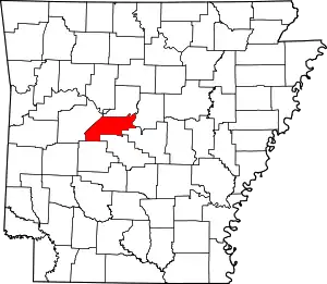 Map of Arkansas highlighting Perry County | |
| Towns | ||
| CDP | ||
| Other unincorporated communities | ||
| Footnotes | ‡This populated place also has portions in an adjacent county or counties | |
This article is issued from Wikipedia. The text is licensed under Creative Commons - Attribution - Sharealike. Additional terms may apply for the media files.