Armorel, Arkansas | |
|---|---|
 Armorel  Armorel | |
| Coordinates: 35°55′20″N 89°48′03″W / 35.92222°N 89.80083°W | |
| Country | United States |
| State | Arkansas |
| County | Mississippi |
| Area | |
| • Total | 1.48 sq mi (3.8 km2) |
| • Land | 1.39 sq mi (3.6 km2) |
| • Water | 0.09 sq mi (0.2 km2) |
| Elevation | 259 ft (79 m) |
| Population | |
| • Total | 312 |
| • Density | 223.8/sq mi (86.4/km2) |
| Time zone | UTC-6 (Central (CST)) |
| • Summer (DST) | UTC-5 (CDT) |
| ZIP code | 72310 |
| Area code | 870 |
| FIPS code | 05-02230 |
| GNIS feature ID | 2805619[2] |
Armorel is an unincorporated community and census-designated place (CDP) in Mississippi County, Arkansas, United States. As of the 2020 census, it had a population of 312.[3] It is in a largely rural area with most of its land devoted to forests and farms. Most of the town lies between Arkansas highways 18 and 312.
The town was founded in 1899 by lumber magnate and president of Lee Wilson and Company, R.E.L. Wilson as one of his many company holdings. Wilson was an eclectic and colorful figure with vast land holdings in the Delta area after the Civil War. Also a proponent of education, Wilson was one of the original trustees of Arkansas State University, then A & M College. He sat on the board from 1917 until his death in 1933.
The town's name was formed from the abbreviations of Arkansas and Missouri, along with the first three initials of its founder, Wilson.
Education
Public education for early childhood, elementary and secondary education is available from the Armorel School District,[4] that leads to graduation from Armorel High School.
Demographics
| Census | Pop. | Note | %± |
|---|---|---|---|
| 2020 | 312 | — | |
| U.S. Decennial Census[5] 2020[6] | |||
2020 census
| Race / Ethnicity | Pop 2020[6] | % 2020 |
|---|---|---|
| White alone (NH) | 272 | 87.18% |
| Black or African American alone (NH) | 23 | 7.37% |
| Native American or Alaska Native alone (NH) | 0 | 0.00% |
| Asian alone (NH) | 4 | 1.28% |
| Pacific Islander alone (NH) | 0 | 0.00% |
| Some Other Race alone (NH) | 0 | 0.00% |
| Mixed Race/Multi-Racial (NH) | 4 | 1.28% |
| Hispanic or Latino (any race) | 9 | 2.88% |
| Total | 312 | 100.00% |
Notable People
- Joey L. Carr, American politician and resident of Armorel
See also
- Marie, Arkansas: company town founded by R.E.L. Wilson
- Victoria, Arkansas: company town founded by R.E.L. Wilson
- Wilson, Arkansas: company town founded by R.E.L. Wilson
References
- ↑ "2021 U.S. Gazetteer Files". United States Census Bureau. Retrieved April 8, 2022.
- 1 2 U.S. Geological Survey Geographic Names Information System: Armorel, Arkansas
- 1 2 "Armorel CDP, Arkansas: 2020 DEC Redistricting Data (PL 94-171)". U.S. Census Bureau. Retrieved April 8, 2022.
- ↑ "2020 CENSUS - SCHOOL DISTRICT REFERENCE MAP: Mississippi County, AR" (PDF). 2020 U.S. Census. U.S. Census Bureau. Retrieved September 20, 2022. - 2010 Map
- ↑ "Decennial Census of Population and Housing by Decades". US Census Bureau.
- 1 2 "P2 HISPANIC OR LATINO, AND NOT HISPANIC OR LATINO BY RACE – 2020: DEC Redistricting Data (PL 94-171) – Armorel CDP, Arkansas". United States Census Bureau.
External links
- Biography of R.E.L. Wilson, founder of Armorel, and of Lee Wilson & Co.
- Armorel Public Schools homepage
- Armorel-Huffman Volunteer Fire Dept.homepage
Municipalities and communities of Mississippi County, Arkansas, United States | ||
|---|---|---|
| Cities | 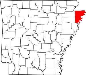 Map of Arkansas highlighting Mississippi County | |
| Towns | ||
| CDP | ||
| Unincorporated communities | ||
| Footnotes | ‡This populated place also has portions in an adjacent county or counties | |