Ahuachapán | |
|---|---|
 | |
 Flag  Coat of arms | |
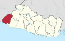 Location within El Salvador | |
| Coordinates: 13°52′01″N 89°53′31″W / 13.867°N 89.892°W | |
| Country | |
| Created | 1869 |
| Seat | Ahuachapán |
| Area | |
| • Total | 1,239.6 km2 (478.6 sq mi) |
| • Rank | Ranked 8th |
| Population | |
| • Total | 333,406 |
| • Rank | Ranked 7th |
| • Density | 270/km2 (700/sq mi) |
| Time zone | UTC−6 (CST) |
| ISO 3166 code | SV-AH |
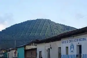
Ahuachapán (Spanish pronunciation: [awatʃaˈpan]) is a department of El Salvador in the west of the country. The capital is Ahuachapán. In the South it has the Apaneca-Ilamatepec Range and the Cerro Grande de Apaneca (Apaneca Grand Hill). Its extension is 1,240 km2 (480 sq mi) and has more than 333,000 people living in the department. The Ahuachapán Department was created by the Legislative Decree of February 9, 1869 under the administration of Francisco Dueñas.
Municipalities
This article is issued from Wikipedia. The text is licensed under Creative Commons - Attribution - Sharealike. Additional terms may apply for the media files.