Aalitaal Rural Municipality
आलिताल गाउँपालिका | |
|---|---|
 Aalitaal Rural Municipality नेपालको नक्शामा आलिताल गाउँपालिका | |
| Coordinates: 29°08′06″N 80°30′45″E / 29.1351°N 80.5124°E | |
| Country | |
| Government | |
| • Type | Local government |
| • Chairperson | Bal B. Gurung |
| • Administrative Head | Ganesh datt Bhatt |
| • Engineer | Aakash Joshi |
| Area | |
| • Total | 292.87 km2 (113.08 sq mi) |
| Population | |
| • Total | 18,531 |
| • Density | 63/km2 (160/sq mi) |
| Time zone | UTC+05:45 (Nepal Standard Time) |
| Website | http://aalitalmun.gov.np/ |
Aalitaal (Nepali: आलिताल) is a Gaupalika in Dadeldhura District in the Sudurpashchim Province of far-western Nepal.[1]
Aalitaal has a population of 18531.The land area is 292.87 km2.[2]
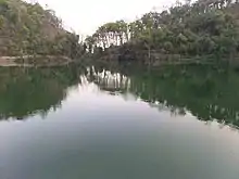
Aalital Lake in Dadheldhura district below the Mahabharat range. It is located at a height of 800m from the sea level
References
- ↑ "Ministry of Federal Affairs". Retrieved 6 July 2020.
- ↑ "National Population and Housing Census 2011(National Report)" (PDF). Central Bureau of Statistics. Government of Nepal. 2012. Archived from the original (PDF) on 2013-04-18. Retrieved 2012-01-01.
Headquarters: Amargadhi | ||
| Municipalities | 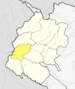 | |
| Rural municipalities | ||
| Former VDCs | ||
List of municipalities and rural municipalities of Nepal | ||
This article is issued from Wikipedia. The text is licensed under Creative Commons - Attribution - Sharealike. Additional terms may apply for the media files.