| Üßbach | |
|---|---|
 | |
| Location | |
| Country | Germany |
| State | Rhineland-Palatinate |
| Districts | Vulkaneifel and Cochem-Zell |
| Reference no. | DE: 2684 |
| Physical characteristics | |
| Source | |
| • location | Near Mosbruch in the county of Vulkaneifel |
| • coordinates | 50°15′39″N 6°57′15″E / 50.260965°N 6.954046°E |
| • elevation | ca. 493 m above sea level (NHN) |
| Mouth | |
• location | Near Alf (Cochem-Zell) into the Alf |
• coordinates | 50°03′29″N 7°06′17″E / 50.058067°N 7.104777°E |
• elevation | ca. 101 m above sea level (NHN) |
| Length | 48.743 km (30.287 mi)[1] |
| Basin size | 184.96 km2 (71.41 sq mi)[1] |
| Basin features | |
| Progression | Alf→ Moselle→ Rhine→ North Sea |
| Landmarks |
|
| Tributaries | |
| • left | Ulmener Bach, Litzbach, Winkelbach, Erdenbach, Purnesbach |
| • right | Schönbach, Hahnenbach, Grundbach, Rosselbach, Elbesbach, Hesselbach, Bonsbeurener Bach, Dauselgraben |
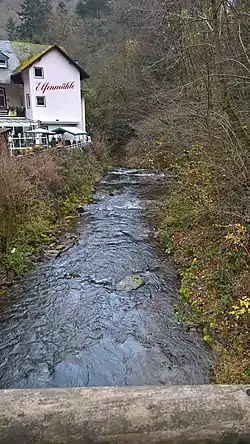
The Üßbach (also Ueßbach[A 1] or Üssbach) is a stream, just under 49 km (30 mi) long in the Eifel in the German state of Rhineland-Palatinate. It rises near Mosbruch in the county of Vulkaneifel and empties near Alf (Cochem-Zell) into the eponymous river, just before the Alf discharges into the river Moselle. The spa resort of Bad Bertrich lies on the Üßbach.
See also
Footnotes
- ↑ For its entry in the Geoexplorer the spelling Ueßbach has to be used.
References
- 1 2 Geoexplorer of the Rhineland-Palatinate Water Authority (Wasserwirtschaftsverwaltung Rheinland-Pfalz) , retrieved 22 January 2014
This article is issued from Wikipedia. The text is licensed under Creative Commons - Attribution - Sharealike. Additional terms may apply for the media files.