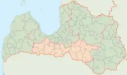
Zemgale Planning Region
Zemgales plānošanas reģions | |
|---|---|
 Coat of arms | |
 | |
| Coordinates: 56°30′0″N 23°30′0″E / 56.50000°N 23.50000°E | |
| Country | Latvia |
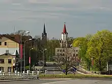
| Largest city | Jelgava |
| Area | |
| • Planning Region | 10,742 km2 (4,148 sq mi) |
| • Urban | 645 km2 (249 sq mi) |
| Population (2022)[1] | |
| • Planning Region | 225,017 |
| • Density | 26.11/km2 (67.6/sq mi) |
| Gross Regional Product | |
| • Total | €2.449 billion |
| • Per capita | €10,714 |
| HDI (2017) | 0.816[3] very high · 6th |
| Website | zemgale.lv |
Zemgale Planning Region (Latvian: Zemgales plānošanas reģions) is a planning region of Latvia located within the south-center of the country.[4] Established in 2002, the planning region contains 22 municipalities: 20 local governments and two major cities, the largest being Jelgava.[5][6] As of 2020, the region's population was 228,409.[7]
Geography
Zemgale is located within the historical region of Semigallia, which encompasses the southern-central portion of the country. The planning region has a total area of 10,742 km2 (4,148 sq mi), making up 16% of the nation's total territory.[8] Zemgale shares a 270 km (170 mi) border with the Republic of Lithuania, which sits directly to its south.[9]
Zemgale is noted for its rich soil, unpolluted resources, and natural areas; 40% of the region is forested.[9][8]
Economy
The gross regional product (GRP) of the region was €2.5 billion in 2020.[10]
Demography
As of 2010, the region has a population of 280,494, which makes up 12.5% of Latvia's total population.[9] About half of Zemgale's population lives in the region's two largest cities: Jelgava and Jekabpils.
See also
References
- ↑ "ISG020. Population number and its change by statistical region, city, town, 21 development centres and county". Central Statistical Bureau of Latvia. 2020-01-01. Retrieved 2021-02-12.
- ↑ "Gross domestic product in regions". www.stat.gov.lv.
- ↑ "Sub-national HDI - Area Database - Global Data Lab". hdi.globaldatalab.org. Retrieved 2019-08-25.
- ↑ Berzina, Inga (2011). "The Zemgale Planning Region Geoportal - Experience for Rural Development". ortus.rtu.lv. Retrieved 2019-01-16.
- ↑ "Zemgale planning region". latlit.eu. Retrieved 2019-01-16.
- ↑ "BEA-APP - Zemgale Planning Region". www.balticenergyareas.eu. Retrieved 2019-01-16.
- ↑ "ISG020. Population number and its change by statistical region, city, town, 21 development centres and county". Central Statistical Bureau of Latvia. 2020-01-01. Retrieved 2021-02-12.
- 1 2 "Zemgale Planning Region, Latvia". www.eu2020goinglocal.eu. Retrieved 2019-01-16.
- 1 2 3 "DEVELOPMENT PLANNING OF ZEMGALE" (PDF).
- ↑ "Gross domestic product by region and city (at current prices) – Territorial unit, Indicator and Time period".