| Haddington Hill | |
|---|---|
 Wendover Woods near the summit of Haddington Hill | |
| Highest point | |
| Elevation | 267 m (876 ft)[1] |
| Prominence | 180 m (590 ft) |
| Parent peak | Cleeve Hill |
| Listing | Marilyn, County Top |
| Coordinates | 51°46′18″N 0°42′42″W / 51.77171°N 0.71154°W |
| Geography | |
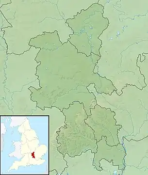 Haddington Hill Haddington Hill in Buckinghamshire | |
| Location | Chiltern Hills, England |
| OS grid | SP890089 |
| Topo map | OS Landranger 165 |
| Name | Grid ref | Height | Status |
|---|---|---|---|
| Pavis Wood | SP914091 | 244 m (801 ft) | County Top |
Haddington Hill (also called Wendover Hill[2]) is a hill in The Chilterns, and the highest point in the English county of Buckinghamshire. On the north-eastern flank is Coombe Hill, not to be confused with another Coombe Hill 4 kilometres (2.5 mi) to the south-west.
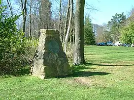
Haddington Hill is owned by the Forestry Commission, whose Wendover Woods cover much of the hill. Many tracks run through the forest, and a car park is located near the summit among the trees: the flat summit means the precise location of the highest point is difficult to determine with certainty. However, in the woods to the east of the car park there are a series of large stones bearing the inscription 'The Chiltern Summit'. The stones are surrounded by trees.
Ascents
The peak is accessible by road, with a car park near the stone. It is also possible to climb on foot.
Pavis Wood
Pavis Wood, the highest point of Hertfordshire, at 244 m (801 ft), is on the eastern ridge of this hill, on the boundary with Buckinghamshire.[1]
See also
References
- 1 2 Bathurst, David (2012). Walking the county high points of England. Chichester: Summersdale. pp. 105–110. ISBN 978-1-84-953239-6.
- ↑ The Hardys – The UK’s High Points at www.thehardys.org. Accessed on 15 Mar 2013.