The Vallum is a huge earthwork associated with Hadrian's Wall in England. Unique on any Roman frontier, it runs practically from coast to coast to the south of the wall.
The earliest surviving mention of the earthwork is by Bede (Historia ecclesiastica gentis Anglorum, I.12), who refers to a vallum, or earthen rampart, as distinct from the wall, or murus; the term is still used despite the fact that the essential element is a ditch, or fossa. It was long thought that the Vallum predated the stone wall, whose most elaborate phasing was presented in 1801 by William Hutton,[1] who thought, wrongly, that the south vallum mound and the marginal mound, with a ditch between, were the work of Agricola, that the vallum ditch and north mound were added by Hadrian, and that the stone wall was the work of Severus. In fact all these elements date to Hadrian's reign, with the stone wall having been built first.
Layout and course
The Vallum comprises a ditch, nominally 6 metres (20 ft) wide and 3 metres (10 ft) deep, with a flat bottom, flanked by two mounds about 6 metres wide and 2 metres (7 ft) high, set back some 9 metres (30 ft) from the ditch edges. For a great deal of its length a third lower mound, the so-called marginal mound occupies the south berm (flat area between mound and ditch), right on the southern lip of the ditch.[2] The total width of the fortification (consisting, from north to south, of mound, berm, ditch, marginal mound, berm, mound) was thus about 36 metres (100 ft).
In several places – for example at Heddon-on-the-Wall and Limestone Corner – the Vallum was cut through solid rock, sometimes for lengthy distances.
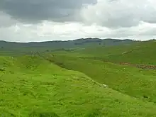
The distance of the Vallum from the Wall varies. In general there was a preference for the earthwork to run close to the rear of the Wall where topography allowed. In the central sector the Wall runs along the top of the crags of the Whin Sill, while the Vallum, laid out in long straight stretches, lies in the valley below to the south, as much as 700 metres (2,300 ft) away.
Archaeology and purpose
Before the middle of the 19th century, the Vallum was most commonly known as Agricola's Ditch, since antiquarians wrongly thought that it had been constructed during the period when Agricola was Governor of Britannia, the Roman province spanning what is now England, Wales and southern Scotland. After John Hodgson published the final portion of his History of Northumberland in 1840,[3] it became generally accepted that the Wall and Vallum had been built during the reign of Hadrian. Hodgson based his view on evidence which included a stone tablet now in the Great North Museum: Hancock, Newcastle upon Tyne, which had been found in Milecastle 38 on the Wall in the previous century, its significance having been overlooked. The inscription on the tablet, probably made and erected to mark the completion of the milecastle, includes the names of Hadrian and Aulus Platorius Nepos (Governor of Britannia during Hadrian's reign), as well as "Legio II Augusta" (Second Augustan Legion). It is now accepted that units of that Roman legion built the section of Hadrian's Wall which includes the milecastle, and they would have automatically included the names of the current emperor and governor on the tablet.[4]
The first excavation was undertaken in 1893 at Great Hill (at Heddon-on-the-Wall, to the west of Newcastle upon Tyne),[5] where it was observed that the Vallum ditch was cut through a seam of fire-clay which was deployed in both mounds. This excavation demonstrated that the main north and south mounds were contemporary and built using material dug from the ditch. In the late 20th century several excavations established that the marginal mound was also contemporary.[6]
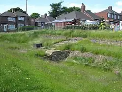
At one time the Vallum was thought to have been constructed some time after the wall was completed, as it deviates to the south around several wall-forts which were either completed or under construction when the wall was nearing completion.[7] There would have been a crossing-point like a causeway or bridge to the south of each wall-fort – several such causeways are known, such as the one still visible with the base of an ornate arch (photo above left) at the fort of Condercum in Benwell, a western suburb of Newcastle. Causeways have also been detected to the south of several milecastles.[8]
Brenda Heywood, in excavations, showed that the Fossa had been dug before the Wall. It was to transport the wall materials and supplies. The metalling that has been found between the ditch and the berm didn’t have access and egress points. Why would you want your horse to wander off the towpath or have other animals ruin the sides of the canal, or put their feet through the feeder aqueducts alongside? Each metre of berm consisted of the seven cubic metres of earth cut, before the inner walls were revetted with stone and puddled clay.
The real reason for the ditch construction is first suggested in the survey, ‘Per Lineam Valli’ by George Neilson in 1891 who walked it. He could not understand why ‘the upcast on the exterior of the ditch... made symmetrical’, and stated that ‘the mound at the margin of the ditch has the effect of raising the south side either to an approach towards equality with... the north side of the ditch...’. ‘Yet this is precisely what has happened for 50 miles’. He also wondered why ‘Where the south side of the ditch was by natural slope appreciably higher than the north side, no marginal mound was found’. Furthermore, Neilson stated that, it is difficult to see how in any way it could help the defence of the north against the south... the phenomenon does not accord with the defence of the north at all.’ ‘No one can dispute that the Wall* almost occupies the strongest possible ground against the north. But the vallum certainly does not, in my opinion, generally occupy ground which is best for defence against a southern foe’. *my capitals. Neilson spotted the problem with defensive theories of the Fossa-Aelium but did not have a reasonable solution. It was left to T C Bell, a marine engineer, who came up with the answer. James Brindley might have spotted it - it was a canal! As Martin Eckholt, who investigated 60 European rivers, states: ‘It is generally accepted that the only way the Romans could have transported cut stone from the quarries was by water’. At some places, the Fossa-Aelium almost meets the Wall and at others where the Wall goes uphill, it is distant; at Heddon, excavations showed the Fossa works were all carried out at the same time. At Limestone Corner it was cut through rock despite the difficulties, whereas the smaller Wall V-ditch there was not even finished. Around Housesteads, where the Fossa-Aelium goes 200 metres south of the fort and the OS have confused the fort’s canal for it, geologist Dr A Bell (not a relative of T C Bell) found that locks and dams of igneous rock had been imported from Whin Sill. West of Walby, the Fossa-Aelium heads southwest, visible on LiDAR maps, splitting into two canals at NY426592, both then heading parallel to each other towards Stanwix. T C Bell had noted these two canals there, but there was no LiDAR then for him to spot the connection, and show that the twin branches of the Fossa-Aelium and the canals he found at Stanwix were one and the same. Roman Canals transportation in Cumbria, and Penrith Roman Town (sites with grid refs): glenriddingcybercafe.co.uk/docs/TCBell/PENRITH_ROMAN_TOWNEVIDENCE.doc
It is thought that the easternmost section of Hadrian's Wall between the forts of Pons Aelius (Newcastle upon Tyne) and Segedunum (Wallsend) was an addition to the original plan. The Vallum was not constructed behind this extra length of the wall, indeed it did not apparently even reach the fort at Newcastle; instead it seems it stopped in the western Newcastle suburb of Elswick. This was because from here on the Vallum's function as a canal to the wall was performed by the River Tyne.
Although there is no definitive historical evidence as to why the Roman army built this unusual barrier, former archaeological opinion is that the Vallum established the southern boundary of an exclusion zone bounded on the north by the wall itself.[9] The zone would have been "out-of-bounds" to civilians and those with no valid reason to be there. It might thus have been the Roman equivalent to a modern demilitarized zone or DMZ, such as the Korean Demilitarized Zone currently separating North Korea and South Korea.
However, this is pure speculation and can be easily disproved as the vallum or Fossa-Aelium sometimes goes right next to the Wall and sometimes a distance from it because of the land gradient - the canal had to stay on almost level land. Some of the Fossa does climb and fall over contours and for that Bell states that they were always filled with running water from streams, rivers and storage pounds by aqueducts or conduits running alongside, feeding a central aqueduct in the undercentre clay puddling of the watercourse. They probably had a simple locking system of gates or guillotine locks similar to portcullis drops. Once full of water they did have protective berms as well, and bridges built across at intervals had gates on the north side. Needless to say, the Fossa- Aelium was not built beyond where it joined the R.Tyne in the east, the river itself was used for waterborne transport here. (At Benwell the ‘only surviving Fossa crossing’ is an imaginary ‘reconstruction’ leading people to believe that the whole work was a V-ditch of this date and that bridges were infilled at the time. They weren’t!)
Sometime in the 2nd century AD, the Vallum was "slighted" – that is, the ramparts were broken through and the ditch filled in at fairly regular intervals along its length where the canal narrows at the former locks. Archaeologists and historians speculated that either the Vallum was then deemed unnecessary, or that it was proving to be a hindrance to military and authorised civilian traffic. This was after the wall was built and no need for the upkeep of the canal was needed. Some have suggested that this coincided with the building of the Antonine Wall in Scotland and the temporary abandonment of Hadrian's Wall.[2]
References
- ↑ Hutton, William (1802). . London: J. Nichols and Son.
- 1 2 Heywood, B. (1966). "The Vallum—Its Problems Restated", in M. G. Jarrett and B. Dobson, eds., Britain and Rome: Essays Presented to Eric Birley. Kendal: Wilson, pp. 85–94
- ↑ John Hodgson (1840). A History of Northumberland. Newcastle: E. Walker.
- ↑ Roger J. A. Wilson (2002). A Guide to the Roman Remains in Britain. London: Constable & Robinson. p. 467.
- ↑ Society of Antiquaries of Newcastle upon Tyne (1894). "First Report of the Committee Appointed to make Excavations per Lineam Valli". Archaeologia Aeliana. 2 (16): xxvi–xxvii.
- ↑ Wilmott, T. (forthcoming). "Four Investigations of the Linear Elements of Hadrian’s Frontier Works, 1980–2000". Hadrian’s Wall: Archaeological Research by English Heritage, 1976–2000, ed. T. Wilmott.
- ↑ Simpson, F. G.; Richmond, I. A. (1937). "The Fort on Hadrian's Wall at Halton". Archaeologia Aeliana. 4 (14): 151–71.
- ↑ Welfare, H. (2000). "Causeways, at Milecastles Across the Ditch of Hadrian’s Wall". Archaeologia Aeliana. 5 (28): 13–25.
- ↑ Bidwell, P. T. (2005). "The System of Obstacles on Hadrian’s Wall: Their Extent, Date and Purpose". Arbeia Journal 8: 53–76.
External links
![]() Media related to Vallum (Hadrian's Wall) at Wikimedia Commons
Media related to Vallum (Hadrian's Wall) at Wikimedia Commons
Forts and structures of Hadrian's Wall | ||
|---|---|---|
| Wall Forts (East to West) |   | |
| Outpost Forts | ||
| Stanegate Forts |
| |
| Supply Forts | ||
| Cumbrian Coast Forts (North to South) |
| |
| Milecastles | ||
| Milefortlets | ||
| Other structures on Hadrian's Wall | ||
| Regular and linear features | ||