| Takahara River | |
|---|---|
 | |
| Native name | 高原川 (Japanese) |
| Location | |
| Country | Japan |
| Physical characteristics | |
| Source | |
| • location | Mount Norikura |
| • elevation | 2,751 m (9,026 ft) |
| Mouth | |
• location | Jinzū River |
| Length | 59.4 km (36.9 mi) |
| Basin size | 781.6 km2 (301.8 sq mi) |
| Discharge | |
| • average | 120 m3/s (4,200 cu ft/s) |
| Basin features | |
| River system | Jinzū River |
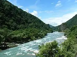
The Takahara River (高原川, Takahara-gawa) has its source at Mount Norikura in the northern part of Gifu Prefecture, Japan, and flows into Toyama Prefecture, where it joins with the Jinzū River. It is a Class 1 River.
The river was polluted with cadmium due to mining at the Kamioka mines (神岡鉱山 Kamioka Kōzan) and caused the itai-itai disease outbreak in downstream towns that began shortly before World War II.
River Communities
The river passes through or forms the boundary of the following communities:
References
External links
36°27′42″N 137°14′53″E / 36.461718°N 137.248153°E (mouth)
| |||||||||||||||
| |||||||||||||||
| |||||||||||||||
| |||||||||||||||
| |||||||||||||||
This article is issued from Wikipedia. The text is licensed under Creative Commons - Attribution - Sharealike. Additional terms may apply for the media files.