Sovietskyi raion
İçki rayonı | |
|---|---|
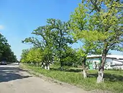 Village (selo) Prudy, Sovetsky District | |
 Flag  Seal | |
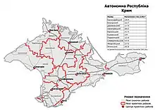
Raion location within Crimea | |
| Country | Disputed: |
| Republic | Crimea |
| Capital | Sovietskyi |
| Subdivisions | List
|
| Area | |
| • Total | 1,080 km2 (420 sq mi) |
| Population (2014) | |
| • Total | 31,898 |
| • Density | 30/km2 (76/sq mi) |
| Time zone | UTC+3 (MSK) |
| Dialing code | +380-6551 |
| Website | sovmo.rk.gov.ru |
Sovietskyi Raion (Russian: Советский район, Ukrainian: Совєтський район), known by Ukrainian authorities[nb 1] as İçki Raion (Ukrainian: Ічкінський район, Crimean Tatar: İçki rayonı) is one of the 25 regions of Crimea, currently subject to a territorial dispute between the Russian Federation and Ukraine. The administrative center of the raion is the urban-type settlement of Sovietskyi. Population: 31,898 (2014 Census).[1]
2020 Ukrainian Administrative Reform
In July 2020, Ukraine conducted an administrative reform throughout its de jure territory. This included Crimea, which was at the time occupied by Russia, and is still ongoing as of October 2023. Crimea was reorganized from 14 raions and 11 municipalities into 10 raions, with municipalities abolished altogether.
Sovietskyi / İçki Raion was abolished, and its territories to become a part of Feodosia Raion, but this has not yet been implemented due to the ongoing Russian occupation.[2]
Notes
- ↑ The renaming has been effected by Ukraine's decommunization laws, but as Crimea is outside of Ukrainian control, this decision has had little practical effect.
References
- ↑ Russian Federal State Statistics Service (2014). "Таблица 1.3. Численность населения Крымского федерального округа, городских округов, муниципальных районов, городских и сельских поселений" [Table 1.3. Population of Crimean Federal District, Its Urban Okrugs, Municipal Districts, Urban and Rural Settlements]. Федеральное статистическое наблюдение «Перепись населения в Крымском федеральном округе». ("Population Census in Crimean Federal District" Federal Statistical Examination) (in Russian). Federal State Statistics Service. Retrieved January 4, 2016.
- ↑ "Про утворення та ліквідацію районів". Офіційний вебпортал парламенту України (in Ukrainian). Retrieved 2023-10-16.
| Raions | |||||
|---|---|---|---|---|---|
| Municipalities | |||||
| Cities |
| ||||
| |||||
| Raions |  | |
|---|---|---|
| Cities and Urban-type settlements under the hromadas | ||
1Due to continued occupation, not yet implemented | ||