The Scottish Islands Portal
Welcome! — Fàilte! — Walcome!
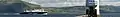
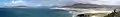
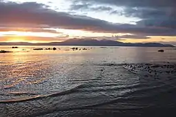
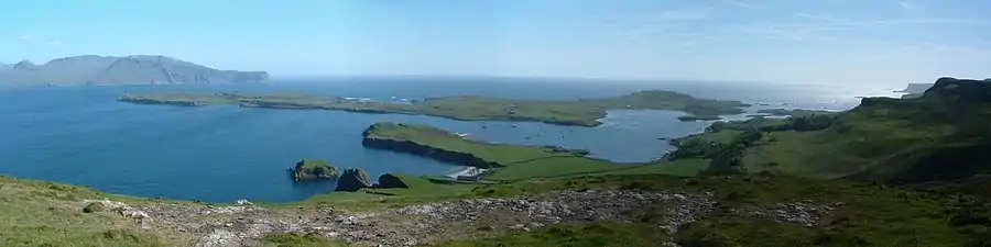
 Looking from the Isle of Mull towards Ardnamurchan peninsula as the Caledonian MacBrayne ferry MV Clansman sails past the Rubha nan Gall lighthouse
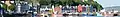

_P-SCO_Banner.jpg.webp)
_P-SCO_Banner.jpg.webp)

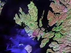
Scotland has around 900 offshore islands, most of which are to be found in four main groups: Shetland, Orkney, and the Hebrides, sub-divided into the Inner Hebrides and Outer Hebrides. There are also clusters of islands in the Firth of Clyde, Firth of Forth, and Solway Firth, and numerous small islands within the many bodies of fresh water in Scotland including Loch Lomond and Loch Maree. The largest island is Lewis and Harris which extends to 2,179 square kilometres, and there are a further 200 islands which are greater than 40 hectares in area. Of the remainder, several such as Staffa and the Flannan Isles are well known despite their small size. Some 94 Scottish islands are permanently inhabited, of which 89 are offshore islands. Between 2001 and 2011 Scottish island populations as a whole grew by 4% to 103,702.
The geology and geomorphology of the islands is varied. Some, such as Skye and Mull, are mountainous, while others like Tiree and Sanday are relatively low lying. Many have bedrock made from ancient Archaean Lewisian Gneiss which was formed 3 billion years ago; Shapinsay and other Orkney islands are formed from Old Red Sandstone, which is 400 million years old; and others such as Rùm from more recent Tertiary volcanoes. Many of the islands are swept by strong tides, and the Corryvreckan tide race between Scarba and Jura is one of the largest whirlpools in the world. Other strong tides are to be found in the Pentland Firth between mainland Scotland and Orkney, and another example is the "Grey Dog" between Scarba and Lunga. (More on Scottish islands...)
Selected picture
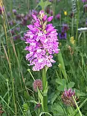
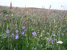 Wildflowers in machair, a coastal dune grassland found in the Outer Hebrides and elsewhere
Credit: Jon Thomson
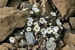 Shetland mouse-ear, a rare plant species unique to Shetland and found only on two serpentine hills in the Keen of Hamar reserve on the island of Unst
Credit: Melvin Grey
.jpg.webp)
 Barra Airport is the only one in the world to use a beach as a regular runway
Barra Airport is the only one in the world to use a beach as a regular runwayCredit: Steve Houldsworth

.jpg.webp)
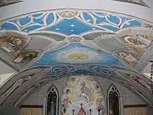 The Italian Chapel on Lamb Holm, Orkney was built from two Nissen huts by Italian prisoners of war during World War 2; the interior frescoes are by Domenico Chiocchetti
Credit: Renata
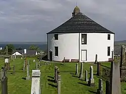 Kilarrow Parish Church, known as the Round Church, is a Georgian building in Bowmore on Islay
Credit: Ronsteenvoorden
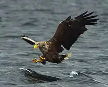 White-tailed eagle fishing off Mull, one of several islands to which the birds have been successfully re-introduced
Credit: Jacob Spinks

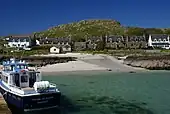 Baile Mòr, the village on Iona
Credit: Clydecoast
 The tied island of St Ninian's Isle is joined to the Shetland Mainland by the largest tombolo in the UK
Credit: ThoWi
 The Bruichladdich distillery, one of eight on Islay; single-malt whisky is a major product of the islands
Credit: Bdcl1881
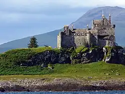 Duart Castle, a 13th-century castle on Mull, the historical seat of Clan Maclean
Credit: Philippe Giabbanelli
 The 1st-century Dun Carloway on Lewis is a well-preserved example of an Iron Age broch, a type of complex Atlantic roundhouse only found in Scotland
Credit: Morris R. Maciver
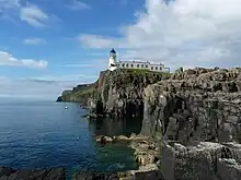 Neist Point Lighthouse on Skye was designed by David Alan Stevenson and dates from 1909
Credit: Lionel Ulmer
 Skye Bridge, opened in 1995; the toll was lifted in 2004
Credit: Gene Selkov
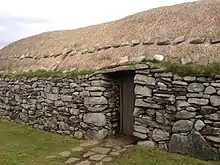 Blackhouses were the traditional form of house across the Hebrides and the Highlands; this example is at Arnol, Lewis
Credit: LornaMCampbell
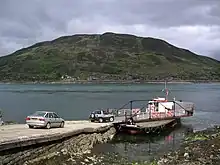 The ferry from Glenelg to Kylerhea on Skye has run for 400 years; the present boat, MV Glenachulish, is the only hand-operated turntable ferry still in operation
Credit: Wojsyl
.jpg.webp)
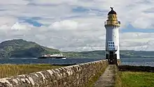 Rubha nan Gall lighthouse, Tobermory, Mull, built in 1857 by David and Thomas Stevenson, with a Caledonian MacBrayne ferry in the background
Credit: Colin

_2.jpg.webp)
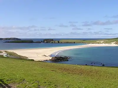
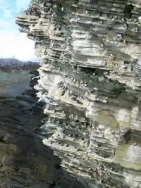
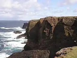 The cliffs of Eshaness, North Mainland, Shetland
Credit: ThoWi
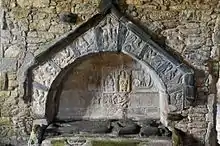 Alasdair Crotach MacLeod is the first McLeod not to be buried on Iona; his tomb on Harris dates from 1528, and is among the finest of this period in Scotland
Credit: Gvdwiele
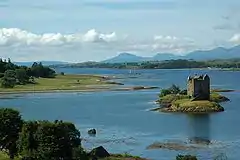
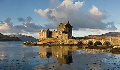 Eilean Donan Castle at the confluence of three sea lochs, Loch Duich, Loch Long and Loch Alsh
Credit: Diliff
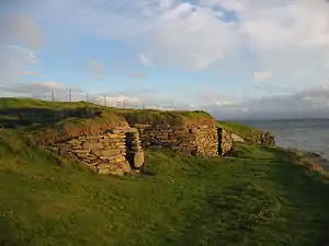 The Neolithic farmstead of Knap of Howar on Papa Westray, Orkney, dates from 3700 BC and might be the oldest surviving stone dwelling in northern Europe
Credit: Me677
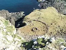 Aerial view of the ruins of a hermitage on Canna
Credit: Peter Van den Bossche
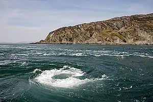 The Corryvreckan Whirlpool in the narrow Gulf of Corryvreckan between Jura and Scarba
Credit: Walter Baxter
.jpg.webp)
Selected island group
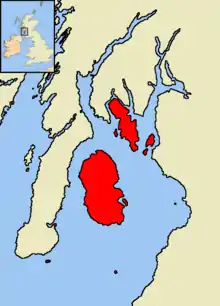
The Islands of the Firth of Clyde are the fifth largest of the major Scottish island groups after the Inner and Outer Hebrides, Orkney and Shetland. They are situated in the Firth of Clyde between Ayrshire and Argyll and Bute. There are about forty islands and skerries. Only four are inhabited, and only nine are larger than 40 hectares (99 acres). The largest and most populous are Arran and Bute. They are served by dedicated ferry routes, as are Great Cumbrae and Holy Island. Unlike the isles in the four larger Scottish archipelagos, none of the isles in this group are connected to one another or to the mainland by bridges.
The geology and geomorphology of the area is complex, and the islands and the surrounding sea lochs each have distinctive features. The influence of the Atlantic Ocean and the North Atlantic Drift create a mild, damp oceanic climate. There is a diversity of wildlife, including three species of rare endemic trees.
The larger islands have been continuously inhabited since Neolithic times. The cultures of their inhabitants were influenced by the emergence of the kingdom of Dál Riata, beginning in 500 AD. The islands were then politically absorbed into the emerging kingdom of Alba, led by Kenneth MacAlpin. During the early Middle Ages, the islands experienced Viking incursions. In the 13th century, they became part of the Kingdom of Scotland. (Full article...)
News
- 12 February: The BiFab construction yard at Arnish near Stornoway, Isle of Lewis, is purchased by InfraStrata.
- 11 February: Wild fires occur in Benbecula; and at Achmore and Sildinish in the Isle of Lewis; Horsaclete in Harris; Brevig in Barra; and Eubhal in North Uist.
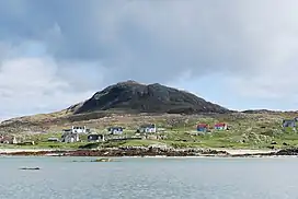
- 19 January: Barra and Vatersay are put under tier-4 restrictions after an outbreak of Covid-19.
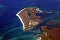
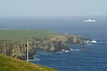
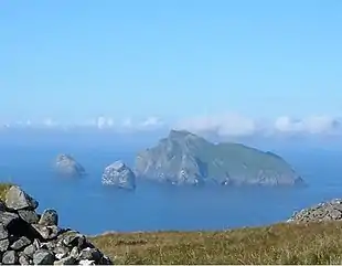
- 18 January: The Shetland Space Centre submits plans for a spaceport on Unst (proposed site pictured), Shetland, including three rocket launch pads.
- 8 January: Distilleries in Orkney and South Uist receive government grants to research ways of reducing their CO2 emissions.
- 4 January: After the UK leaves the European Union, the Northern Celt, an Irish fishing boat based out of Greencastle, County Donegal, is ordered to leave the 12-nautical-mile zone around Rockall by officers of Marine Scotland.
- 1 January: A total of 72 cases of Covid-19 are recorded in an ongoing outbreak in Shetland.
- 9 December: A review by a committee of MSPs into the commissioning and building of two new dual-fuel Caledonian MacBrayne ferries, MV Glen Sannox and "hull 802", criticises CMAL, Transport Scotland and the Scottish government, as well as the ship builders, Ferguson Marine.
- 3 December: North-east Lewis, Sea of the Hebrides and Shiant East Bank are designated Marine Protected Areas, while East Mainland Coast Shetland, Sound of Gigha, Coll and Tiree, Rùm, the west coast of the Outer Hebrides, and the waters off St Kilda and Foula are designated Special Protection Areas.
- 30 November: Michael Russell, MSP for Argyll and Bute, and David Stewart and John Finnie, MSPs for the Highlands and Islands region, will stand down at the 2021 election.
- 17 November: Phytophthora ramorum-infected larch trees in Arran are to be felled over a 543-acre area, to prevent the fungus-like pathogen from spreading.
- 4 November: The Scottish Wildlife Trust objects to a proposed salmon farm in the Marine Protected Area of Wester Ross, near Horse Island, Summer Isles, because of the potential impact on kelp forests and maerl beds.
Selected fauna
_specimen%252C_Kelvingrove%252C_Glasgow_-_geograph.org.uk_-_1108249.jpg.webp)
The great auk (Pinguinus impennis) is a species of flightless alcid that became extinct in the mid-19th century. It was the only modern species in the genus Pinguinus. It is not closely related to the Southern Hemisphere birds now known as penguins, which were discovered later by Europeans and so named by sailors because of their physical resemblance to the great auk, which were called penguins.
It bred on rocky, remote islands with easy access to the ocean and a plentiful food supply, a rarity in nature that provided only a few breeding sites for the great auks. When not breeding, they spent their time foraging in the waters of the North Atlantic, ranging as far south as northern Spain and along the coastlines of Canada, Greenland, Iceland, the Faroe Islands, Norway, Ireland, and Great Britain.
The bird was 75 to 85 centimetres (30 to 33 inches) tall and weighed about 5 kilograms (11 pounds), making it the largest alcid to survive into the modern era, and the second-largest member of the alcid family overall (the prehistoric Miomancalla was larger). It had a black back and a white belly. The black beak was heavy and hooked, with grooves on its surface. During summer, great auk plumage showed a white patch over each eye. During winter, the great auk lost these patches, instead developing a white band stretching between the eyes. The wings were only 15 cm (6 in) long, rendering the bird flightless. Instead, the great auk was a powerful swimmer, a trait that it used in hunting. Its favourite prey were fish, including Atlantic menhaden and capelin, and crustaceans. Although agile in the water, it was clumsy on land. Great auk pairs mated for life. They nested in extremely dense and social colonies, laying one egg on bare rock. The egg was white with variable brown marbling. Both parents participated in the incubation of the egg for around six weeks before the young hatched. The young left the nest site after two to three weeks, although the parents continued to care for it.
The great auk was an important part of many Native American cultures, both as a food source and as a symbolic item. Many Maritime Archaic people were buried with great auk bones. One burial discovered included someone covered by more than 200 great auk beaks, which are presumed to be the remnants of a cloak made of great auks' skins. Early European explorers to the Americas used the great auk as a convenient food source or as fishing bait, reducing its numbers. The bird's down was in high demand in Europe, a factor that largely eliminated the European populations by the mid-16th century. Scientists soon began to realize that the great auk was disappearing and it became the beneficiary of many early environmental laws, but these proved ineffectual. (Full article...)
Selected history & culture article
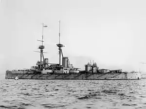
HMS Vanguard was one of three St Vincent-class dreadnought battleships built for the Royal Navy in the first decade of the 20th century. She spent her career assigned to the Home and Grand Fleets. Aside from participating in the Battle of Jutland in May 1916 and the inconclusive action of 19 August several months later, her service during World War I mostly consisted of routine patrols and training in the North Sea.
Shortly before midnight on 9 July 1917 at Scapa Flow, Vanguard suffered a series of magazine explosions. She sank almost instantly, killing 843 of the 845 men aboard. The wreck was heavily salvaged after the war, but was eventually protected as a war grave in 1984. It was designated as a controlled site under the Protection of Military Remains Act 1986, and diving on the wreck is generally forbidden. (Full article...)
Selected island
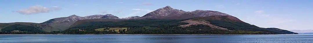
The Isle of Arran (/ˈærən/; Scottish Gaelic: Eilean Arainn) or simply Arran is an island off the west coast of Scotland. It is the largest island in the Firth of Clyde and the seventh-largest Scottish island, at 432 square kilometres (167 sq mi). Historically part of Buteshire, it is in the unitary council area of North Ayrshire. In the 2011 census it had a resident population of 4,629. Though culturally and physically similar to the Hebrides, it is separated from them by the Kintyre peninsula. Often referred to as "Scotland in Miniature", the Island is divided into highland and lowland areas by the Highland Boundary Fault and has been described as a "geologist's paradise".
Arran has been continuously inhabited since the early Neolithic period. Numerous prehistoric remains have been found. From the 6th century onwards, Goidelic-speaking peoples from Ireland colonised it and it became a centre of religious activity. In the troubled Viking Age, Arran became the property of the Norwegian crown, until formally absorbed by the kingdom of Scotland in the 13th century. The 19th-century "clearances" led to significant depopulation and the end of the Gaelic language and way of life. The economy and population have recovered in recent years, the main industry being tourism. However, the increase in tourism and people buying holiday homes on the Island, the second highest rate of such homes in the UK, has led to a shortage of affordable homes on the Island. There is a diversity of wildlife, including three species of tree endemic to the area.
The Island includes miles of coastal pathways, numerous hills and mountains, forested areas, rivers, small lochs and beaches. Its main beaches are at Brodick, Whiting Bay, Kildonan, Sannox and Blackwaterfoot. (Full article...)
Did you know?
.jpg.webp)
- ... that Domhnall mac Raghnaill (descendant pictured) was the founder of the MacDonald clan?
- ... that nearly 10,000 quartz artifacts were found at a Neolithic site known as the Scord of Brouster?
- ... that the Boreray is the most critically endangered breed of sheep in the United Kingdom, according to the Rare Breeds Survival Trust?
- ... that the Raven banner, a standard used by various Viking leaders including Sigurd the Stout and Harald III of Norway, was a totem believed to have the power to grant victory to its holder?
Selected portrait
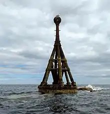 The North Carr Beacon at low tide; the unlit beacon was built between 1813 and 1821 by Robert Stevenson to warn shipping of the North Carr Reef near Fife Ness
Credit: Kathrinpassig
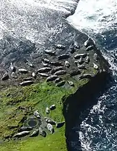 Seals hauled out by Lyrie Geo on Hoy
Credit: Claire Pegrum
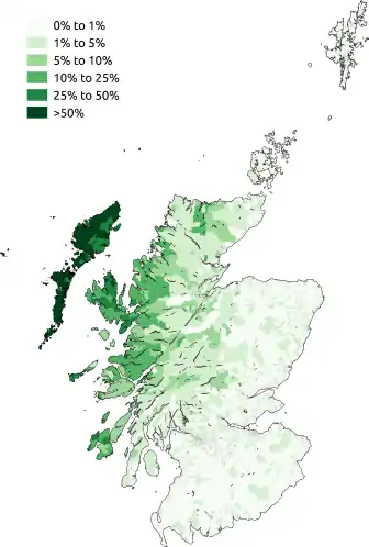 Scottish Gaelic speakers in the 2011 census; the Outer Hebrides, Tiree, Raasay, Skye and Lismore have the highest proportion of speakers
Credit: SkateTier
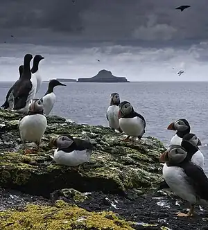 Puffins and guillemots on Lunga in the Treshnish Isles, with Bac Mòr (known as Dutchman's Cap for its distinctive shape) in the background
Credit: Simaron
 The 8th-century Kildalton Cross, Islay, one of the best-preserved Celtic crosses in Scotland
Credit: Tom Richardson
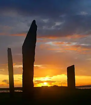 The Standing Stones of Stenness, near Stromness, Orkney, started by 3100 BC and possibly Britain's oldest henge site
Credit: Fantoman400
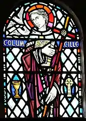 Columba was a 6th-century Irish-born saint who spread Christianity in Scotland and founded Iona Abbey, where he is commemorated in this stained-glass window
Credit: Vegansoldier
Selected geography article

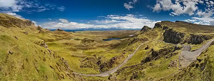
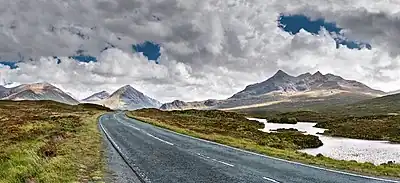
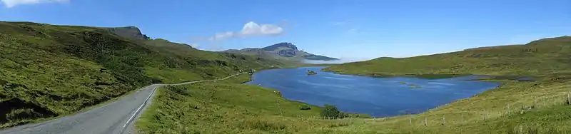
Trotternish or Tròndairnis (Scottish Gaelic) is the northernmost peninsula of the Isle of Skye, in Scotland. Its most northerly point, Rubha Hùinis, is the most northerly point of Skye.
One of the peninsula's better-known features is the Trotternish landslip, a massive landslide that runs almost the full length of the peninsula, some 30 kilometres (20 miles). The landslip contains two of Skye's most famous landmarks: the Old Man of Storr, an isolated rocky pinnacle, and the Quiraing, an area of dramatic and unusual rock formations. The summit of The Storr, on whose slopes the Old Man of Storr is located, is the highest point of the peninsula. The north-eastern part of the peninsula around Quiraing is designated as a National Scenic Area and the entire landslip is a Special Area of Conservation.
Dinosaur footprints have been found at An Corran, which is also a Mesolithic hunter-gatherer site dating to the 7th millennium BC. The ruins of the 14th–15th-century Duntulm Castle stand at the northern end of the peninsula.
The three major settlements on Trotternish are Portree, generally regarded as the capital of Skye, Uig, a ferry terminus, and Staffin. Trotternish is the strongest Gaelic-speaking area of Skye. (Full article...)
Selected biography
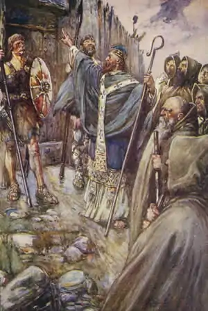
Saint Columba (/kəˈlʌmbəˌ ˈkɒlʌmbə/) or Colmcille (7 December 521 – 9 June 597 AD) was an Irish abbot and missionary evangelist credited with spreading Christianity in what is today Scotland at the start of the Hiberno-Scottish mission. He founded the important abbey on Iona, which became a dominant religious and political institution in the region for centuries. He is the patron saint of Derry. He was highly regarded by both the Gaels of Dál Riata and the Picts, and is remembered today as a Catholic saint and one of the Twelve Apostles of Ireland.
Columba studied under some of Ireland's most prominent church figures and founded several monasteries in the country. Around 563 AD he and his twelve companions crossed to Dunaverty near Southend, Argyll, in Kintyre before settling in Iona in Scotland, then part of the Ulster kingdom of Dál Riata, where they founded a new abbey as a base for spreading Celtic Christianity among the pagan Northern Pictish kingdoms. He remained active in Irish politics, though he spent most of the remainder of his life in Scotland. Three surviving early medieval Latin hymns may be attributed to him. (Full article...)
Related portals
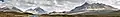
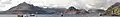
Selected panorama
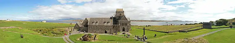 Iona Abbey
Credit: Oliver-Bonjoch
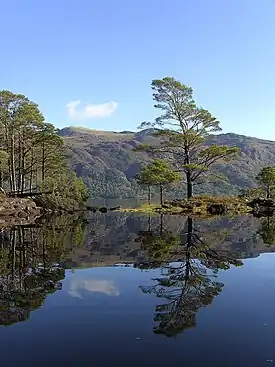
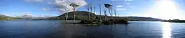 Small freshwater islets on Loch Assynt
Credit: Vincent
 Eilean Donan
Credit: Stefan Krause
Topics
|  | ||||||||||||||||
|
| |||||||||||||||||
| |||||||||||||||||
| |||||||||||||||||
| |||||||||||||||||
| |||||||||||||||||
| |||||||||||||||||
| |||||||||||||||||
Categories
The main category is Islands of Scotland, with subcategories
Things you can do
- Add new articles to the project by placing {{WPSI|class=|importance=}} on the talk page
- Add a link to the portal in the "See also" section of relevant articles with {{Portal|Scottish islands}}
- Take requested photographs or create requested pages, including Prehistoric Hebrides, Trialabreac, Dog Isle...
- Expand a Scottish Islands stub into a full article, adding images, citations, references and infoboxes; did you know that if you expand one 5x, you can nominate it for Did You Know?
- Improve one of the highest priority articles, including Mull, Bute, North & South Uist, Columba, Highland Clearances, Sorley MacLean, St Magnus Cathedral...
- Follow these hints to improve a B-class article and nominate it for Good Article

- Suggest articles, pictures, interesting facts, events and news to be featured here on the portal
Wikiproject
Scotland • UK Geography • Islands
Associated Wikimedia
The following Wikimedia Foundation sister projects provide more on this subject:
-
 Commons
Free media repository -
 Wikibooks
Free textbooks and manuals -
 Wikidata
Free knowledge base -
 Wikinews
Free-content news -
 Wikiquote
Collection of quotations -
 Wikisource
Free-content library -
 Wikiversity
Free learning tools -
 Wikivoyage
Free travel guide -
 Wiktionary
Dictionary and thesaurus
-
 List of all portalsList of all portals
 -
 The arts portal
 -
 Biography portal
 -
 Current events portal
 -
 Geography portal
 -
 History portal
 -
 Mathematics portal
 -
 Science portal
 -
 Society portal
 -
 Technology portal
 -
 Random portalRandom portal
 -
 WikiProject PortalsWikiProject Portals