|
Maryland Portal |
Baltimore Task Force |
Frederick Task Force |
Montgomery Task Force |
WikiProject Maryland |
|
Main page |
Discussion |
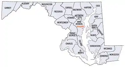
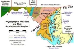
Introduction Maryland (US: /ˈmɛrɪlənd/ ⓘ MERR-il-ənd) is a state in the Mid-Atlantic region of the United States. It borders Virginia, West Virginia, and Washington, D.C., to its south and west; Pennsylvania to its north; and Delaware and the Atlantic Ocean to its east. With a total land area of 12,407 square miles (32,130 km2), Maryland is the eighth-smallest state by land area, and its population of 6,177,224 ranks it the 18th-most populous state and the fifth-most densely populated. Baltimore is the largest city in the state, and the capital is Annapolis. The western portion of the state contains numerous stretches of the Appalachian Mountains, while the central portion is primarily composed of the Piedmont. The eastern side of the state makes up the Chesapeake Bay, sharing the border with Delaware, and the southeastern side borders the Atlantic Ocean. Among its occasional nicknames are Old Line State, the Free State, and the Chesapeake Bay State. It is named after Henrietta Maria, the French-born queen of England, Scotland, and Ireland, who was known then in England as Mary. Before its coastline was explored by Europeans in the 16th century, Maryland was inhabited by several groups of Native Americans – mostly by Algonquian peoples and, to a lesser degree, Iroquoian and Siouan. As one of the original Thirteen Colonies of England, Maryland was founded by George Calvert, 1st Baron Baltimore, a Catholic convert who sought to provide a religious haven for Catholics persecuted in England. In 1632, Charles I of England granted Lord Baltimore a colonial charter, naming the colony after his wife, Henrietta Maria. Unlike the Pilgrims and Puritans, who rejected Catholicism in their settlements, Lord Baltimore envisioned a colony where people of different religious sects would coexist under the principle of toleration. Accordingly, in 1649 the Maryland General Assembly passed an Act Concerning Religion, which enshrined this principle by penalizing anyone who "reproached" a fellow Marylander based on religious affiliation. Nevertheless, religious strife was common in the early years, and Catholics remained a minority, albeit in greater numbers than in any other English colony. Maryland's early settlements and population centers clustered around rivers and other waterways that empty into the Chesapeake Bay. Its economy was heavily plantation-based and centered mostly on the cultivation of tobacco. Demand for cheap labor from Maryland colonists led to the importation of numerous indentured servants and enslaved Africans. In 1760, Maryland's current boundaries took form following the settlement of a long-running border dispute with Pennsylvania. Maryland was an active participant in the events leading up to the American Revolution, and by 1776, its delegates signed the Declaration of Independence. Many of its citizens subsequently played key political and military roles in the war. In 1790, the state ceded land for the establishment of the U.S. capital of Washington, D.C. (Full article...)
|


.svg.png.webp)
| Non-Hispanic White 40–50% 50–60% 60–70% 70–80% 80–90% 90%+ |
Black or African American 50–60% 60–70% |
.jpg.webp)


In the news
- November 1, 2007 - Westboro Baptist Church ordered to pay US$11 million to family of fallen US soldier
- September 30, 2007 - Interview with gay marriage movement founder Evan Wolfson
- September 1, 2007 - Four jackpot winners confirmed in US 'Mega Millions' lottery drawing
- May 20, 2007 - Horse racing: Curlin wins 2007 Preakness Stakes
On this day...
 Good article -
The Johns Hopkins–Maryland lacrosse rivalry is an intercollegiate rivalry between the Johns Hopkins Blue Jays, which represent Johns Hopkins University, and the Maryland Terrapins, which represent the University of Maryland. The most prominent event has been the men's lacrosse series, which is widely regarded as one of the greatest rivalries in the sport. More than 115 contests in the series have been played since the schools first met in 1895. The competition is intensified by each program's status as a traditional lacrosse powerhouse. As such, the game has often held national championship implications, and twice the teams played to represent the United States in the Olympics.
The schools currently meet only in lacrosse, as all other Johns Hopkins athletics fall under NCAA Division III and all Maryland athletics are Division I. From the late 19th into the 20th century, however, their football teams also competed regularly. More recently, the schools have played in women's lacrosse. (Full article...)Selected article -
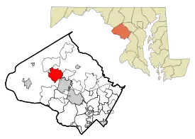
Germantown is an urbanized census-designated place in Montgomery County, Maryland. With a population of 91,249 as of the 2020 census, it is the third most populous place in Maryland, after Baltimore and Columbia. Germantown is located approximately 28 miles (45 km) outside the U.S. capital of Washington, D.C., and is an important part of the Washington metropolitan area.
Germantown was founded in the early 19th century by European immigrants, though much of the area's development did not take place until the mid-20th century. The original plan for Germantown divided the area into a downtown and six town villages: Gunners Lake Village, Kingsview Village, Churchill Village, Middlebrook Village, Clopper's Mill Village, and Neelsville Village. The Churchill Town Sector at the corner of Maryland Route 118 and Middlebrook Road most closely resembles the center of Germantown because of the location of the Upcounty Regional Services Center, the Germantown Public Library, the Black Rock Arts Center, and pedestrian shopping that features an array of restaurants. Three exits to Interstate 270 [I-270] are less than one mile away, the Maryland Area Regional Commuter train is within walking distance, and the Germantown Transit Center that provides Ride On shuttle service to the Shady Grove station of the Washington Metro's Red Line. (Full article...)Did you know?
- ...that unlike most other American courts, the judges on the Maryland Court of Appeals wear crimson (not black) robes, and neck bands, reminiscent of British court dress?
- ...that Kent Island was founded in 1631 as part of Virginia, three years before St. Mary's City was founded?
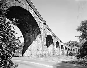
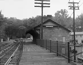
- ...that the Thomas Viaduct (pictured) over the Patapsco River was the first multi-span masonry railroad bridge in the United States when it was constructed between 1833 and 1835?
Subcategories
Topics
.svg.png.webp)
Related portals
Associated Wikimedia
The following Wikimedia Foundation sister projects provide more on this subject:
-
 Commons
Free media repository -
 Wikibooks
Free textbooks and manuals -
 Wikidata
Free knowledge base -
 Wikinews
Free-content news -
 Wikiquote
Collection of quotations -
 Wikisource
Free-content library -
 Wikiversity
Free learning tools -
 Wikivoyage
Free travel guide -
 Wiktionary
Dictionary and thesaurus
-
 List of all portalsList of all portals
 -
 The arts portal
 -
 Biography portal
 -
 Current events portal
 -
 Geography portal
 -
 History portal
 -
 Mathematics portal
 -
 Science portal
 -
 Society portal
 -
 Technology portal
 -
 Random portalRandom portal
 -
 WikiProject PortalsWikiProject Portals