| Mona Reservoir | |
|---|---|
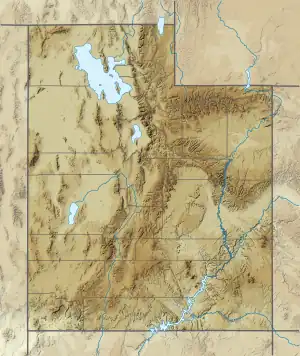 Mona Reservoir  Mona Reservoir | |
| Location | Juab County, Utah |
| Coordinates | 39°49′15″N 111°52′04″W / 39.82083°N 111.86778°W |
| Type | reservoir |
| Primary inflows | Currant Creek |
| Primary outflows | Currant Creek |
| Basin countries | United States |
Mona Reservoir is a large reservoir on Currant Creek in the north end of Juab Valley, Juab County, Utah. It was created in 1895 by the construction of an earthen dam.
%252C_UTAH_-_NARA_-_523950.jpg.webp)
Currant Creek region south of Mona Reservioir inlet, at Mona, Utah; (1872, view east to Mount Nebo (Utah)
External links
- "Report on Mona Reservoir" (PDF). (86.7 KiB) by the Utah Division of Water Quality
- U.S. Geological Survey Geographic Names Information System: Mona Reservoir
This article is issued from Wikipedia. The text is licensed under Creative Commons - Attribution - Sharealike. Additional terms may apply for the media files.