| Huntleys Point Sydney, New South Wales | |||||||||||||||
|---|---|---|---|---|---|---|---|---|---|---|---|---|---|---|---|
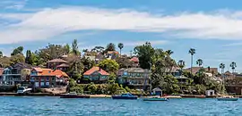 Huntleys Point from the Parramatta River | |||||||||||||||
| Population | 144 (2016 census)[1] | ||||||||||||||
| Postcode(s) | 2111 | ||||||||||||||
| Location | 9 km (6 mi) north-west of Sydney CBD | ||||||||||||||
| LGA(s) | Municipality of Hunter's Hill | ||||||||||||||
| State electorate(s) | Lane Cove | ||||||||||||||
| Federal division(s) | North Sydney | ||||||||||||||
| |||||||||||||||
Huntleys Point is a suburb on the Lower North Shore of Sydney, in the state of New South Wales, Australia. Huntleys Point is located nine kilometres north-west of the Sydney central business district, in the local government area of the Municipality of Hunter's Hill. Huntleys Point sits on the northern shore of the Parramatta River.
Gallery
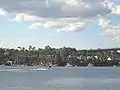 Huntleys Point, view from Chiswick
References
- ↑ Australian Bureau of Statistics (27 June 2017). "Huntleys Point (State Suburb)". 2016 Census QuickStats. Retrieved 15 January 2018.
External links
33°50′20″S 151°08′49″E / 33.839°S 151.147°E
This article is issued from Wikipedia. The text is licensed under Creative Commons - Attribution - Sharealike. Additional terms may apply for the media files.