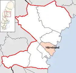
Härnösand Municipality
Härnösands kommun | |
|---|---|
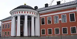 Härnösands Town Hall | |
 Coat of arms | |
 | |
| Coordinates: 62°38′N 17°56′E / 62.633°N 17.933°E | |
| Country | Sweden |
| County | Västernorrland County |
| Seat | Härnösand |
| Area | |
| • Total | 1,938.58 km2 (748.49 sq mi) |
| • Land | 1,058.36 km2 (408.64 sq mi) |
| • Water | 880.22 km2 (339.85 sq mi) |
| Area as of 1 January 2014. | |
| Population (31 December 2021)[2] | |
| • Total | 25,012 |
| • Density | 13/km2 (33/sq mi) |
| Time zone | UTC+1 (CET) |
| • Summer (DST) | UTC+2 (CEST) |
| ISO 3166 code | SE |
| Province | Ångermanland |
| Municipal code | 2280 |
Härnösand Municipality (Swedish: Härnösands kommun) is a municipality in Västernorrland County, northern Sweden. Its seat is located in Härnösand (pop. 18,000).
The present municipality was formed in 1969 through the amalgamation of the City of Härnösand with Säbrå (itself created in 1952 when five former entities were merged) and Högsjö.
Villages
References
- ↑ "Statistiska centralbyrån, Kommunarealer den 1 januari 2014" (in Swedish). Statistics Sweden. 2014-01-01. Archived from the original (Microsoft Excel) on 2016-09-27. Retrieved 2014-04-18.
- ↑ "Folkmängd i riket, län och kommuner 31 december 2021" (in Swedish). Statistics Sweden. February 22, 2022. Retrieved February 22, 2022.
External links
 Media related to Härnösand Municipality at Wikimedia Commons
- Härnösand - Official site
Places adjacent to Härnösand Municipality | ||||||||||||||||
|---|---|---|---|---|---|---|---|---|---|---|---|---|---|---|---|---|
| ||||||||||||||||
Municipalities and seats of Västernorrland County | ||
|---|---|---|
| Municipalities | ||
| Municipal seats | ||
This article is issued from Wikipedia. The text is licensed under Creative Commons - Attribution - Sharealike. Additional terms may apply for the media files.