| Hawk's Tor | |
|---|---|
 Hawk's Tor | |
| Highest point | |
| Elevation | 329 m (1,079 ft)[1] |
| Prominence | 36 m (118 ft)[1] |
| Listing | Tump |
| Geography | |
| Location | East Bodmin Moor, Cornwall |
| OS grid | SX253763 |
| Topo map | OS Landranger 201, Explorer 109 |
| Geology | |
| Mountain type | granite tor |
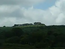
Hawk's Tor is an elongated hill, 329 metres (1,079 ft) high and running from WSW to ENE, on Bodmin Moor in the county of Cornwall, England, UK.[2] It stands opposite the village of North Hill across the valley of the River Lynher.[2]
There is another Hawk's Tor (307 m) on Bodmin Moor, further west, near the village of Blisland.[2]
References
- 1 2 Hawk's Tor at www.hill-bagging.co.uk. Retrieved 28 Dec 2016.
- 1 2 3 Ordnance Survey 1:25,000 Explorer map series, No. 109
50°33′41″N 4°28′57″W / 50.5613°N 4.4826°W
This article is issued from Wikipedia. The text is licensed under Creative Commons - Attribution - Sharealike. Additional terms may apply for the media files.