| Hathmati | |
|---|---|
 | |
| Location | |
| Country | India |
| State | Gujarat |
| Physical characteristics | |
| Source | Aravalli Range |
| • location | India |
| Mouth | |
• location | Sabarmati River, India |
• coordinates | 23°30′49″N 72°49′29″E / 23.5135°N 72.8248°E |
| Discharge | |
| • location | Sabarmati River |
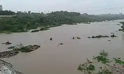
The Hathamati River is a river of western India, in Gujarat, whose origin is in the Aravali Range hills. It is one of the left-bank tributaries of the Sabarmati River. The Hathmati river system includes the Hathamati Dam near Himatnagar. The Guhai River is a tributary of the Hathmati River.[1][2]
Bhiloda and Himatnagar are the main towns on the banks of this river.
In fiscal year 1899-1900, a channel was cut from the Hathmati Canal to the Khari River to capture rainy season overflow for irrigation from the Khari Cut.[3]
References
- ↑ "Hathmati River". guj-nwrws.gujarat.gov.in, Government of Gujarat. Retrieved 4 May 2017.
- ↑ "Sabarmati River". guj-nwrws.gujarat.gov.in, Government of Gujarat. Retrieved 4 May 2017.
- ↑ Public Works Department (1900). "Deccan and Gujarat". Administration Report of Irrigation Works in the Bombay Presidency, with Accounts and Statistical Statements. Bombay: Government Central Press. p. 12.
This article is issued from Wikipedia. The text is licensed under Creative Commons - Attribution - Sharealike. Additional terms may apply for the media files.