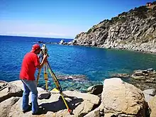
Geomatics engineering is a rapidly developing engineering discipline which focuses on spatial information (i.e. information that has a location). The location is the primary factor used to integrate a very wide range of data for spatial analysis and visualization. Geomatics engineers design, develop, and operate systems for collecting and analyzing spatial information about the land, the oceans, natural resources, and manmade features.[1]
Geomatics engineers apply engineering principles to spatial information and implement relational data structures involving measurement sciences, thus using geomatics and acting as spatial information engineers. Geomatics engineers manage local, regional, national and global spatial data infrastructures. Geomatics engineering also involves aspects of Computer Engineering, Software Engineering and Civil Engineering.[2]
History
Geographic information systems inspired geologists since Alfred Wegener first formalized Continental drift in 1912, later to evolve into Plate tectonics on the discovery of a spreading system in the early 1960s.[3]
The more traditional land surveying strand of geomatics engineering is concerned with the determination and recording of boundaries and areas of real property parcels, and the preparation and interpretation of legal land descriptions. The tasks more closely related to civil engineering include the design and layout of public infrastructure and urban subdivisions, and mapping and control surveys for construction projects.[4]
Significance
Geomatics is a field that incorporates several others such as the older field of land surveying engineering along with many other aspects of spatial data management ranging from data science and cartography to geography. Following the advanced developments in digital data processing, the nature of the tasks required of the professional land surveyor has evolved significantly in recent years, and for more and more people the term "surveying" no longer accurately covers the whole range of tasks that the profession deals with. As our societies become more complex, information with a spatial position associated with it becomes more critical to decision-making, both from a personal and a business perspective, and also from a community and a large-scale governmental viewpoint.[5]
In different schools and in different countries the same education curriculum is administered with the name surveying in some, and in others with the names geomatics, civil engineering surveying, geomatics engineering, geospatial (information) engineering, surveying engineering, or geodesy and geoinformatics. While these occupations were at one time often taught in civil engineering education programs, more and more universities include the departments relevant for geo-data sciences under informatics, computer science or applied mathematics. These facts demonstrate the breadth, depth and scope of the highly interdisciplinary nature of geomatics engineering. The job of geospatial engineer is well established in the U.S. military.[6][7]
See also
References
- ↑ colorlib. "Department of Geomatics Engineering | Kathmandu University". Department of Geomatics Engineering. Retrieved 2023-11-16.
- ↑ "Marshall, Wesley". engineering.ucdenver.edu. Retrieved 2023-11-16.
- ↑ "Continental Drift versus Plate Tectonics". education.nationalgeographic.org. Retrieved 2023-11-17.
- ↑ "Surveying and geospatial sciences". www.rmit.edu.au. Retrieved 2023-11-16.
- ↑ "Bachelor in Geomatics Engineering program, BE Geomatics, TU, Tribhuvan University, | Colleges Nepal". www.collegesnepal.com. Retrieved 2023-11-16.
- ↑ "Geospatial Engineer". goarmy.com. Retrieved 2023-11-16.
- ↑ "Army National Guard". www.nationalguard.com. Retrieved 2023-11-16.
