Dashtestan County
Persian: شهرستان دشتستان | |
|---|---|
County | |
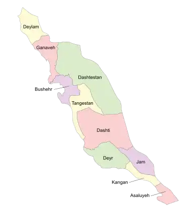 Location of Dashtestan County in Bushehr province (top, green) | |
 Location of Bushehr province in Iran | |
| Coordinates: 29°11′N 51°21′E / 29.183°N 51.350°E[1] | |
| Country | |
| Province | Bushehr |
| Capital | Borazjan |
| Districts | Central, Ab Pakhsh, Bushkan, Eram, Sadabad, Shabankareh |
| Area | |
| • Total | 6,327 km2 (2,443 sq mi) |
| Population (2016) | |
| • Total | 252,047 |
| • Density | 40/km2 (100/sq mi) |
| Time zone | UTC+3:30 (IRST) |
| Dashtestan County can be found at GEOnet Names Server, at this link, by opening the Advanced Search box, entering "9206093" in the "Unique Feature Id" form, and clicking on "Search Database". | |
Dashtestan County (Persian: شهرستان دشتستان) is in Bushehr province, Iran. Its capital is the city of Borazjan.
At the 2006 census, the county's population was 222,226 in 47,773 households.[2] The following census in 2011 counted 229,425 people in 57,562 households,[3] by which time Darvahi Rural District and the city of Ab Pakhsh had been separated from Shabankareh District in the establishment of Ab Pakhsh District.[4] At the 2016 census, the county's population was 252,047 in 70,943 households.[5]
The people of this district revolted against Nader Shah in September 1746.[6] In June 1747 they captured Bushehr.
Administrative divisions
The population history and structural changes of Dashtestan County's administrative divisions over three consecutive censuses are shown in the following table. The latest census shows six districts, 12 rural districts, and nine cities.[5]
| Administrative Divisions | 2006[2] | 2011[3] | 2016[5] |
|---|---|---|---|
| Central District | 124,291 | 128,334 | 145,460 |
| Dalaki RD | 10,490 | 11,761 | 12,208 |
| Howmeh RD | 6,838 | 8,148 | 9,603 |
| Ziarat RD | 6,881 | 6,932 | 6,646 |
| Borazjan (city) | 92,221 | 95,449 | 110,567 |
| Dalaki (city) | 7,861 | 6,044 | 6,436 |
| Ab Pakhsh District | 21,352 | 23,132 | |
| Darvahi RD | 3,056 | 3,211 | |
| Dashti-ye Esmail Khani RD | 1,058 | 1,008 | |
| Ab Pakhsh (city) | 17,238 | 18,913 | |
| Bushkan District | 12,242 | 11,915 | 12,943 |
| Bushkan RD | 4,409 | 4,181 | 2,434 |
| Poshtkuh RD | 5,896 | 5,570 | 5,911 |
| Bushkan (city) | 2,135 | ||
| Kalameh (city) | 1,937 | 2,164 | 2,463 |
| Eram District | 14,551 | 13,375 | 13,659 |
| Dehrud RD | 5,507 | 5,072 | 5,372 |
| Eram RD | 6,116 | 5,120 | 5,045 |
| Tang-e Eram (city) | 2,928 | 3,183 | 3,242 |
| Sadabad District | 31,928 | 33,272 | 33,513 |
| Vahdatiyeh RD | 2,120 | 1,717 | 1,724 |
| Zirrah RD | 11,666 | 12,282 | 12,319 |
| Sadabad (city) | 7,119 | 7,859 | 8,248 |
| Vahdatiyeh (city) | 11,023 | 11,414 | 11,222 |
| Shabankareh District | 39,214 | 20,022 | 22,348 |
| Darvahi RD | 4,546 | ||
| Shabankareh RD | 12,391 | 12,369 | 14,448 |
| Ab Pakhsh (city) | 15,302 | ||
| Shabankareh (city) | 6,975 | 7,653 | 7,900 |
| Total | 222,226 | 229,425 | 252,047 |
| RD: Rural District | |||
References
- ↑ OpenStreetMap contributors (30 March 2023). "Dashtestan County" (Map). OpenStreetMap. Retrieved 30 March 2023.
- 1 2 "Census of the Islamic Republic of Iran, 1385 (2006)". AMAR (in Persian). The Statistical Center of Iran. p. 18. Archived from the original (Excel) on 20 September 2011. Retrieved 25 September 2022.
- 1 2 "Census of the Islamic Republic of Iran, 1390 (2011)" (Excel). Iran Data Portal (in Persian). The Statistical Center of Iran. p. 18. Retrieved 19 December 2022.
- ↑ Ahmadinejad, Mahmoud (7 May 1388). "Approval letter regarding reforms and divisional changes in Bushehr province". Islamic Council Research Center (in Persian). Ministry of Interior, Council of Ministers. Archived from the original on 26 August 2021. Retrieved 14 November 2023.
- 1 2 3 "Census of the Islamic Republic of Iran, 1395 (2016)". AMAR (in Persian). The Statistical Center of Iran. p. 18. Archived from the original (Excel) on 3 August 2017. Retrieved 19 December 2022.
- ↑ "Power Struggles and Trade in the Gulf (1620-1820)". sheikhdrsultan.ae. Retrieved 17 February 2021.
Bushehr Province, Iran | |||||||||||||||||||||
|---|---|---|---|---|---|---|---|---|---|---|---|---|---|---|---|---|---|---|---|---|---|
| Capital | 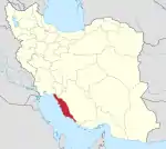 | ||||||||||||||||||||
| Counties and cities |
| ||||||||||||||||||||
| Landmarks |
| ||||||||||||||||||||
| populated places | |||||||||||||||||||||
| Capital | |||||||||||||||||||||||||||||||||||||||||||||||||||||||||||||
|---|---|---|---|---|---|---|---|---|---|---|---|---|---|---|---|---|---|---|---|---|---|---|---|---|---|---|---|---|---|---|---|---|---|---|---|---|---|---|---|---|---|---|---|---|---|---|---|---|---|---|---|---|---|---|---|---|---|---|---|---|---|
| Districts |
| ||||||||||||||||||||||||||||||||||||||||||||||||||||||||||||